The devastating impacts of climate change are now more visible than ever.
Take the fact that in recent years we have seen global wildfires become increasingly unpredictable, with even areas like Dartmoor National Park in Devon being affected. Plus, at the other extreme, more of us are living with the ongoing threat of coastal flooding. In fact, the Climate Change Committee (CCC) predicts that by 2080, up to 1.5 million properties, including 1.2 million homes, may be at significant flood risk across the UK. With such growing dangers, it is now essential we can observe, analyse and forecast natural disasters, and act, so we can limit the damage these events cause communities worldwide. So, what can we do to tackle these growing issues?
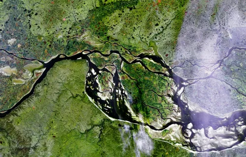
Space-based observation: seeing the bigger picture
Space-based Earth Observation is an invaluable tool for keeping people safe from the dangerous effects of climate change. Using geospatial data and satellite imagery, we can now monitor and assess our environment by capturing data that fuels a variety of sustainable initiatives and helps predict catastrophic natural events. Using a new generation of satellites launched into orbit over the last few years, this technology can observe where vulnerabilities are and evaluate the success of human remediation strategies.
Space has a long history of being used for environmental monitoring, but the scale and quality of data now available presents many new opportunities for tracking changes and implementing solutions for improving sustainability.
Here is a taste of how space is helping us overcome key environmental challenges:
Monitoring and managing forests
Forest fires are an essential part of many forest ecosystems but, worldwide, the areas affected by forest fires every year continue to rise, becoming more extreme and less predictable. By using satellites with AI-enabled technology, we can map and monitor forests around the world, improving the prediction and detection of changes to limit destruction.
Maintaining peatland’s ability to store carbon
Peatland is an important lifeline for our planet’s biodiversity and stores vast amounts of carbon, but rising temperatures are putting it increasingly at risk. In fact, damaged peatlands contribute to around 10% of greenhouse emission from the land use sector. To help prevent further decline, Sentinel satellites can now create accurate, up-to-date maps of vast areas of peatland using motion monitoring. These can then be used to alert farmers in vulnerable areas to stop draining peat and identify where rewetting might stop additional drying.
Keeping the world’s greenhouses efficient and productive
A growing global population is increasing the pressure on food supplies. Greenhouses are an essential part of ensuring food security - but they need to be managed efficiently and sustainably. By capturing infrared and radar signals on the surface of the earth, the Greenhouse Early Warning Service can detect early changes in conditions, spot potential damage, and reduce the need for physical inspections, which can also save growers time and money.
Improving coastal surge defences and response
Rising sea levels, subsidence, and coastal infrastructure are all putting us at greater risk from flooding. Satellite data can be used for precise tidal forecasting, alerting organisations to possible coastal surges days before they can affect people or property.
Start imagining your tomorrow
This only scratches the surface of what is possible with space-based data. Increasingly, more researchers and organisations are realising it has exciting potential to open our horizons to more sustainable practices.
Here at CGI, we have worked in the space industry for over 40 years and are committed to tackling the climate crisis by supporting global efforts.
Our work, alongside expert customers and academic collaborators, highlights the power of space data today and shines a light on how it might be used in the future such as: Producing high resolution maps of greenhouse gas emissions to monitor and police nations’ commitments on climate change, as well as to measure the effectiveness of potential solutions.
Monitoring global agriculture and food production systems to increase the resilience of our food supplies and avoid future food shortages, while developing new sustainable approaches. Improving the forecasting of extreme weather to reduce the number of people dying during heatwaves and flood conditions.
Helping businesses and organisations to evaluate and reduce their environmental impact and achieve sustainable operations.
If you would like to find out how space-based data can support your business’s efforts towards a more sustainable future, please get in touch.
About this author

Dr Jaime Reed
Vice President Consulting Services, Space Data Platforms and Applications
Jaime enjoys working with clients to invent and deliver the space services of the future. He leads Space Data Platforms and Applications team for CGI in the UK and Australia. We deliver a range of services for satellite operators including network operations and business operations ...