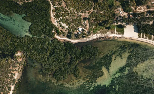
Mangroves are clusters of tropical trees with the ability to store vast amounts of carbon. They thrive in seawater.
Rich in biodiversity, these coastal “blue carbon” ecosystems improve water quality, provide essential habitats to endangered species, help slow coastal erosion, act as a natural flood defense, and contribute to regional food and economic needs.
However, every year, 1% of mangrove habitats disappear, equivalent to the release of 520 million barrels of CO2.
Madagascar’s mangrove forests represent approximately 20% of Africa’s mangroves and 2% of the global mangrove habitat. Unfortunately, human activity and climatic pressures are leading to the degradation and deforestation of this environment.
For Planète Urgence, the situation required immediate action. Field observations in this region proved difficult, and no diagnosis had been carried out since 2010.
The nongovernmental organization, which operates in seven countries, approached CGI for support in conducting a diagnostic study on the evolution of Madagascar’s mangroves to both preserve and limit degradation. We took on this project on a pro-bono basis.
Relying on our expertise in the space domain, Planète Urgence asked us to quantify changes based on satellite observations, analyze vulnerabilities, and provide results. This, in turn, would enable all stakeholders, including associations, local authorities, and managers, to implement the best urban and economic development policies while preserving the mangrove ecosystem, as well as take actions, in the meantime, aimed at mangrove reforestation.
To achieve the above objectives, we used our unique CGI Earth Observation Solution for Vegetation (CEOS-VEG), a decision-making support tool for territory management and monitoring.
CEOS-VEG first generates maps using satellite images and machine learning algorithms to classify land coverage by mangroves, savannahs, agricultural plots, forests, and buildings. These layers are further analyzed to identify and highlight on the maps areas of mangrove loss or gain that have occurred over the years.
Cross-checking between the various layers helps assess which structures have replaced the mangroves. This enables stakeholders to determine whether degradation has resulted from anthropic pressure due to the introduction of agricultural areas or buildings or as a result of natural pressure through replacement by a savannah or forest.
Thanks to the data and analyses made available by CEOS-VEG, the various actors can also evaluate the effectiveness of reforestation activities carried out in past years by assessing mangrove growth in an area of interest.
Among its discoveries, our solution revealed an average annual mangrove deforestation rate of 16% from 2010–2022 in northwestern Madagascar, with a maximum mangrove loss of 23% in 2020. Of the areas where mangroves disappeared, 58% have since been transformed into agricultural plots.
“We are delighted to rely on CGI’s expertise and the performance of its CEOS-VEG solution,” said Amandine Hersant, General Manager of Planète Urgence. “The solution has enabled the detailed analysis essential for sustainable territorial management with local stakeholders.”
“Our CEOS-VEG solution demonstrates our ESG commitment and reinforces that digital technology has an important role to play in building a sustainable world,” said Jean-Bernard Rodriguez, CGI Senior Vice-President, CGI Senior Vice-President, South of France. “CGI’s portfolio of Earth observation solutions helps clients use satellite data to solve complex challenges by turning space data into actionable information. We are proud to partner with Planète Urgence and use our space expertise to benefit the people of Madagascar.”
As a separate project, Planète Urgence has asked us to extend mangrove surveillance activities to Indonesia, and we have also started tapia surveillance in Madagascar. The surveillance of this last species endemic to Madagascar through satellite images is the first effort of its kind in the world.


